
🏔️ Olympus Marathon® 44K Route Description
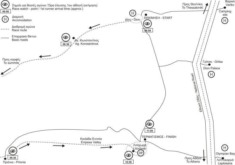
1. The Start: Dion Town
The race starts at the Archaeological site of Dion town, at 3m altitude above sea level. At the beginning, the athletes run on the asphalt road crossing the settlement of Dion.
- The Foothills (5K): Just outside the town, the route moves on an asphalt country road in a slight ascending incline, reaching the foothills at 150m altitude.
- Entering the Trail (6K): After some road twists, the athletes leave the road to enter the trail that will be followed for the next 36km.
2. Orlias Canyon & Koromilia
The trail starts moving in the Orlias Canyon with dense bush vegetation, which soon becomes a forest with broad-leafed trees. For quite some time, runners can hear the stream running in the canyon below.
- Change of Scenery: The trail moves away from the canyon and athletes dive into a wonderful pine tree forest.
- Dirt Tracks (K-9): The route crosses a dirt track twice, then once more, following it for about 500m to reach the first station.
3. The Forest Climb: Bara & Petrostrouga
The trail enters the pine forest again and climbs up. It is wide and clear, reaching a forested slope before emerging to a ridge with a wide open view of the mountain's southern peaks.
- Check Point "Bara": Reached at K-13. The trail here is not clearly defined, but frequent marking ensures the right direction.
- Robolo Trees: Ascending towards Petrostrouga, the vegetation includes exclusively the 'robolo', a kind of high-altitude pine tree. The field is fine without loose rocks.
4. Alpine Zone: Skourta & Muses Plateau
Runners follow the main trail to the highest part of the mountain. At K-17, the vegetation becomes bushier and is gradually eliminated as athletes climb above the tree line (2200m).
- Skourta (K-18): Runners view the main complex of Mount Olympus highest peaks for the first time, including the dominating 'Throne of Zeus'.
- Muses Plateau: After an arduous short uphill on a rough field full of sharp loose rocks, athletes reach this high-altitude meadow (2500m+) with a fascinating view in any direction.
5. The Highest Point & The Long Descent
The trail climbs to pass below the 'Throne of Zeus', reaching the highest point of the route (2780m). Then, it follows an endless downhill—the second distinctive part of the race.
- Zonaria: A steep, exposed slope where the trail reaches a deviation point to 'Mytikas' (2918m). Caution: The trail is rough and exposed here!
- The Descent: The trail turns eastward with a clear view of the sea. Countless twists lead through robolo and pine forests until the slope smoothes out into a dense beech forest.
6. Prionia, Enipeas Canyon & Zilnia
About 2km after the beech forest, the trail reaches 'Prionia'. The final part of the race follows the main trail through the beautiful Enipeas Canyon.
- Enipeas Canyon: Passes the old Monastery of Agios Dionisios. After the monastery, leave the E4 path (head straight, NOT right on the wooden bridge).
- Uphill to Handolia: Move close to the river banks, then an uphill climb for 4km on soft terrain with clearings and wonderful views, followed by a 1km descent to Zilnia.
7. The Finish: Litochoro
After Zilnia, the gentle descent continues. Runners get magnificent views of Litochoro, the Gulf of Thermaikos, and Mount Olympus.
- Approaching Town: Pass by the "Samuel estate" and "Kouvari" area. Cross a small metal footbridge (K-43) and move onto a dirt road meeting the first houses of Litochoro.
- The Final Stretch: Enter the asphalt section, cross the "Green bridge" (slight uphill), pass the "Horostasouli" square, the 1st Primary School, and Agios Dimitrios church.
- The Finish Line: Descend towards the Central square with the fountain to finish triumphantly at the Municipal park of Litochoro! 🏁
Update: January 2026