
OLYMPUS ULTRA route description
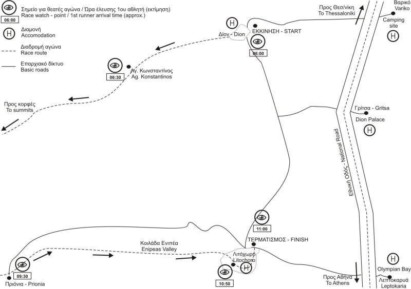
The race starts from the Archaeological site of Dion, at an altitude of 3m above sea level. The first 15km are the same with the Olympus Marathon race. Firstly, the route follows the asphalt road which, after 200m, enters the village “Dion”, located on the west side of the archaeological site. Crossing the village, the route continues on an asphalt road for 1.5 km as it exits the boundaries of the settlement, in a southwest direction. For the next 2 km the road moves steadily in the southwest direction, earning a very slow altitude.
The route leaves the asphalt for one km, following a dirt road initially, which then becomes a path to meet the asphalt road again. After a left turn, the last uphill straight of the street leads to the small chapel of Agios Konstantinos. After 50 meters, the road turns left, the asphalt stops and, on the turn, begins the path to “Koromilia – Petrostrouga”, which the race course follows.
The vegetation at this point is shrubby and the small river of “Orlias (or Ourlias)” is very close to the path. Soon the path rises sharply for a while and passes by the river at KM-7. There is a small water fountain "Itamos", right next to the path, where in an intermediate auxiliary station spring water is offered to the athletes. As the path moves away it begins to gain in height, through very dense vegetation.
For the next 2 km the trail runs uphill in varying angle slopes and different types of vegetation, with the sound of the river coming from the depth of the ravine, on its right side. The path is well marked and the dense vegetation creates the feeling that a little further it is lost, but that does not happen. In the second natural loft that the path meets, there is a sign with the inscription "Orlias"
The slopes are wooded with various types of broadleaf vegetation, mixed with conifers. Immediately afterwards, and as the trail moves away from the Orlias Canyon in a southward direction, the pine vegetation dominates. In KM-9,6 the path meets and crosses a dirt road twice, within a distance of 200 meters. The path meets the dirt road for a third time, at KM-10.1. From there the course follows the dirt road towards its uphill side, for 300 meters and reaches the location “Koromilia” where there is the 1st Station “Koromilia” (alt 1020m, KM-10.5), just in front of the Koromilia Refuge.
The course follows the path again, which starts at the front of the Refuge, on its left sidewalk, climbing within low vegetation with bushy cedars and pine trees, which in a few dozens of meters they become large trees, forming a pine forest. The track at its beginning (first 30 meters) is hardly visible, but immediately afterwards it is well marked and as it ascends becomes even more wide and smooth. After 1.5 km the slope of the path, which progresses continuously on a wooded ridge, is diminished and among the pine forest the first beech trees are emerging. At the location "Bara", KM-13 the path passes through a large typical plateau lying in a dense beech forest.
Then the path sharply turns to the left and rises upwards after a period of minimal climb. From the Refuge of “Koromilia” and up to here, there is a black hard hose that transports drinking water to the Refuge for its needs. The turns are continuous and irregular, in the direction of either right or left.
The course proceeds for a while on a ridge and after passing a steep point with 3-4 concrete steps, it passes to the opposite side of the ridge to a northern slope. Shortly afterward, and while it actually continues on the ridge, the path makes a small “dive” and starts a steep uphill in a beech forest. Approximately in KM-14.5, the path seems to be lost as it spreads up in the beech trees. The feature here is the thick layer of dry leaves that covers the ground, but the marking is frequent so that there is no doubt about the right direction. The athlete has to climb up this slope and everywhere he will find appropriate signs. The end of this section is marked by the end of the beech forest and the entrance to the rocky forest, which is the pine tree with the white trunk that grows at high altitudes.
The path quickly gets smooth in inclination and moves into a landscape of sparse vegetation and sloping meadows. There is KM-15. Shortly after, the trail turns sharply to the left and leads uphill to an extremely sloping meadow at the site called “Petrostrouga”. Large rocky trees are sparse in this area, and there are some summer livestock farming camps. The tall grass and the nettles cover the path, but the 2d Station is visible in front of us “Petrostrouga” (alt 1940m, ΚM-15.3), just a few meters from the Refuge. There we have to change direction and go completely west (leaving the Olympus Marathon route) and after 300m we turn North.
The path descends through a forest, passes through streams and comes to a ridge (sparse vegetation) called "Alataria" (alt 1870m and a distance of 1600m from “Petrostrouga”). From here the path turns west again and immediately after northwest. The sloping downhill steepens but the excellent dense coniferous forest is rewarding. Soon we arrive at “Paliokoprisies” and pass the characteristic stream of "Arapis". The altitude here is 1590m and the total distance from the start is 18.7 km. We climb slightly on the opposite ridge and continue downhill and north.
Soon we arrive at a glade at the "Mastorouli" location where there is the 3d Station “Mastorouli” (alt 1150m, KM-21.9). We completely change direction towards south. In the forest the path sometimes goes uphill and sometimes it descends slightly. Gradually we turn southwest. Eventually it acquires a western direction facing the "Papa" stream. As it descends with manoeuvres, it turns to north. Going down towards the stream, on our right (east) at 25.6 km, there is a path towards “Ag. Apostoloi”. We ignore it and follow the path to the “Krevatia” Refuge. We pass the stream (lower altitude 790m) and ascend to the north. The slope gradually becomes gentle and so in 3km we gain 215m in altitude. We reach the 4th Station “Krevatia Refuge” (alt 1050m KM-29.1).
From here it begins a steep uphill (south direction) in densely wooded path. The goal is “Barbalas" peak at an altitude of 1.842m which we will reach after 3,3 km. Then we turn left and go dowb on a forest road at alt. 1220m. The 650m negative difference in altitude will be made in 3,1 km with repeated manoeuvres. There is the 5th Station Spilies (alt 1330m, KM-40.4).
The forest road that we follow lead us to Xirolaki and after 6 km uphill we reach the 6th Station “Emergency Refuge Christakis” (alt.2550m, KM-46.1), located at the “Megali Gourna” basin.
After the station we take the famous E4 path that leads us to Skolio alt.2910m, the second highest peak of mount Olympus.
From Skolio the route descends to the east and after a small traverse passes next to the peak "Skala". There begins a steep downhill on a flimsy (loose) dirt path in the south direction. Great attention is needed here as the slope is intense and the ground loose. At the end of this steep section, the trail turns eastwards and a traverse leads it to the central path that comes from the Muses plateau. Here we meet the course of Olympus Marathon and we follow it.
The path from here is well marked but with a lot of broken stone (pebbles) that can make it difficult for the athletes, especially those who are stressed by the uphill. It proceeds with several zigzags as it moves on a ridge, called the “Chondromesorahi”, which has rocky trees, sparse and low in the beginning but they become denser as the path descends. On our left we have the view of the high peaks of the mountain. After another 1,5 km and while the vegetation becomes denser and the trees are taller, the path leads us to the refuge "Spilios Agapitos" or "Refuge-A", where there is the 7th Station "Refuge-A" (alt 2100m, KM-51.6). This refuge is well organized and operates six months a year, offering everything to the hikers.
The rocky and rough downhill trail continues in a pine forest without a trace of running water, with the path leading to many abrupt downhill turns, but without any risk for serious fall. Extra attention must be paid to the metal poles that used to hold pieces of tree trunks in order to form steps but now are left “naked”, creating risk for painful falls, as they are barely visible.
At this point athletes will face the problem of the midday heat. Then the path becomes flat and enters a beech forest, relieving the athletes. From this point onwards and for the next 2.5 km, the path proceeds with smaller downhill slopes in a beech forest mixed with pine trees to reach the location "Prionia", where the 8th Station "Prionia" (alt 1050m, KM-57.6).
Here are the springs of the river “Enipeas”. The flow of the river follows the course of the race in its last section. The site “Prionia” is accessible by an asphalt road from Litochoro (18km) and allows friends of the contestants to attend as viewers and to support the athletes that they accompany.
The last section of the race evolves into the Enipeas Canyon and offers a lot of coolness to the athletes, due to dense vegetation and frequent contact with the river and the various springs in the riverbed. River water is drinkable and safe for athletes, as the river supplies with water the city of Litochoro. The slope of the path is gradual and the feeling that it evolves right next to the river creates a positive mood to the athletes. 3 km after Prionia is the monastery of “Agios Dionysios” where is the 9th Station located (alt.890m, KM-61).
Now we leave the E4 path and head straight and NOT to the right on the wooden bridge and for 1Km we move very close to the banks of the river on our right on soft ground. Arriving at ¨sara¨ the path goes up to the left next to the rocks for about 200m. Immediately after this uphill we meet an intersection; we turn left and go uphill for 4km until we reach the place "Handolia".
The route in this part is on soft terrain with ups and downs with characteristic clearings and wonderful views at the bends. Then after about 1Km downhill we reach the forest location "Zilnia" where there is the 10th Station "Zilnia" (alt. 710m, KM-68).
After "Zilnia" the path continues downhill. After 300m, at the fork we take the left path that is before the "Huta horafi" location. The gentle descent continues with several openings, where the athlete sees the magnificent view towards Litochoro, the Gulf of Thermaikos and of course Mount Olympus. Then we proceed to a clearing with flat, gray-white slabs, we continue through the already dense maquis vegetation, pass by the "Samuel estate" and enter the "Kouvari" area. The gentle descent continues on soft terrain and soon leads us to a small metal footbridge, we cross across. We have now done 70km.
At the exit of the bridge, we take the left (eastern) leg of the path, which you move smoothly on a dirt road and then we meet the first houses of Litochoro. Entering the asphalt section, we can see a "Green bridge". There we were now in Litochoro. We head left and UP the bridge on a very slight uphill call. The last kilometer is inside the settlement of Litochoro. After about 400 meters we pass the square "Horostasouli", the historic 1st Primary School and the church of Agios Dimitrios, to descend towards the Central square with the fountain and after 300 meters we reach the Municipal Park of Litochoro town and the Finish of the race.
Update : January 2024